
|
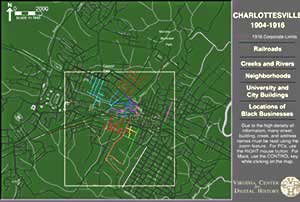
Charlottesville
Map, 1904-1916
This interactive Flash map of Charlottesville highlights railroads, creeks and rivers, university and city buildings, and locations of black businesses during the period 1904-1916.
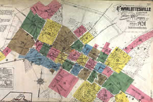
Sanborn
Insurance Maps, Charlottesville Virginia (1920)
Sanborn Maps provide invaluable detail to historians, genealogists,
urban planners, architectural historians, environmentalists, economists,
and many other specialists and scholars. Because of the maps' labeling
of the type, use, building material used in construction, flammable material
on site, and even name of specific buildings in towns and cities they
have become increasingly popular primary sources. Special Collections
at Alderman Library holds the actual map sheets for Charlottesville from
1907 and 1920.